
National Hurricane Center Tracks Humberto and Developing Imelda
The national hurricane center reported that Hurricane Humberto has rapidly intensified into a Category 4 storm with maximum sustained winds reaching 145 mph. Positioned northeast of the northern Leeward Islands, the storm is creating lifethreatening conditions at sea and coastal flooding risks.
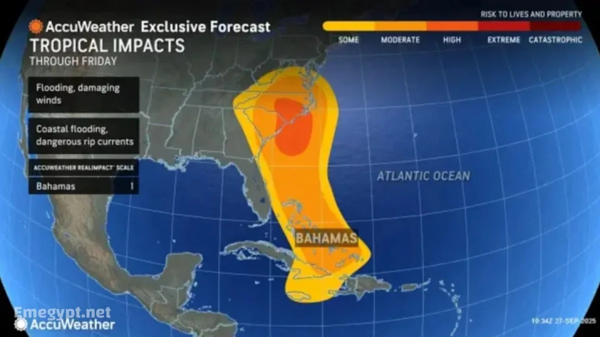
Meanwhile, a tropical disturbance designated AL94 is expected to strengthen into Tropical Storm Imelda. Forecasters warn that Imelda could bring torrential rains and strong winds to Cuba, Hispaniola, and the Bahamas before potentially steering toward the southeastern U.S. coastline.
The following table summarizes the current situation:
| Storm System | Status | Location | Potential Threats |
|---|---|---|---|
| Humberto | Category 4 Hurricane | Northeast of Leeward Islands | High winds, dangerous surf, storm surge, heavy rain |
| AL94 (Imelda) | Developing system | Near Cuba, Hispaniola, Bahamas | Torrential rains, flooding, possible U.S. impact |
National Oceanic and Atmospheric Administration Forecasts AboveAverage Season
The National Oceanic and Atmospheric Administration previously projected a highly active Atlantic hurricane season in 2025, estimating between 13 and 19 named storms. Out of these, 5 to 9 were expected to become hurricanes, including 2 to 5 major hurricanes. Humberto’s explosive growth into a Category 4 storm underscores the accuracy of these warnings.
Forecasters also note that warming sea surface temperatures and favorable atmospheric conditions are fueling storm development, making it more likely that additional tropical cyclones will form in the weeks ahead.
NOAA Hurricane Outlook Warns of Continued Risk
According to the NOAA hurricane outlook, the most dangerous period of the season traditionally extends through late September and October. With multiple systems forming simultaneously, the risk of storm interaction — such as the Fujiwhara effect, where two storms orbit around each other — is being monitored closely.
This phenomenon could alter storm tracks significantly, potentially shielding or exposing U.S. coastlines depending on how the systems behave.
Tropical Cyclone Forecasting Focuses on Storm Interaction
Meteorologists at the national hurricane center emphasize that storm interaction is one of the most challenging elements of tropical cyclone forecasting. If Humberto and the developing Imelda system come within close proximity, their tracks could shift dramatically.
Forecast scenarios include:
-
Humberto pulling the weaker storm eastward and away from the U.S.
-
Imelda being absorbed into Humberto, reducing its individual threat.
-
Both storms strengthening and redirecting paths toward populated coastlines.
Atlantic Hurricane Season 2025: Local Impacts Already Being Felt
Communities across the Caribbean are already experiencing severe weather conditions. Heavy rainfall and gusty winds have led to red alerts in the Dominican Republic, while flood evacuations are underway in vulnerable areas.
In the United States, South Carolina has declared a state of emergency as Charleston and surrounding coastal cities prepare for potential flooding, storm surge, and wind damage. Marine warnings are also in place, with officials cautioning against travel by sea due to dangerous rip currents and swells.
Hurricane Warnings and Storm Surge Forecasts
The national hurricane center has issued warnings covering both Humberto and the developing Imelda system. Key alerts include:
-
Caribbean Islands: Flood warnings, wind advisories, and evacuation orders in floodprone areas.
-
Southeastern U.S.: Coastal surge forecasts show significant flooding potential, with rip currents and marine hazards already observed.
-
Bermuda and Puerto Rico: Dangerous surf and rip current conditions expected to worsen.
What to Expect Next from the National Hurricane Center
The national hurricane center continues to provide sixhourly advisories, updating storm track forecasts, wind speeds, and rainfall projections. Over the coming days, close attention will be given to:
-
Whether Imelda strengthens and where it makes landfall.
-
The potential Fujiwhara effect between Humberto and Imelda.
-
Coastal impacts in South Carolina, Georgia, and Florida.
-
Additional tropical waves emerging off the coast of Africa that may develop.
By combining historical data, modern satellite technology, and realtime storm modeling, the national hurricane center aims to reduce uncertainty and keep vulnerable communities prepared. With the Atlantic hurricane season 2025 showing no signs of slowing down, vigilance remains essential across the region.