
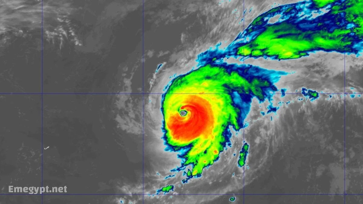
Current Status of Hurricane Gabrielle
Hurricane Gabrielle developed rapidly, gaining strength over warm waters and favorable atmospheric conditions. The storm’s eye remains clearly defined, surrounded by bands of intense thunderstorms. Forecasters caution that while slight weakening is expected in the coming days due to wind shear and drier air, the system will remain a dangerous hurricane for the near future.
Key details about Gabrielle’s current intensity:
-
Sustained winds: ~140 mph (220 kph)
-
Status: Category 4 major hurricane
-
Movement: Eastnortheast, approaching the Azores
Gabrielle Hurricane Path and Forecast
The Gabrielle hurricane path continues to shift slightly, but the overall forecast keeps the storm moving toward the Azores archipelago. The National Hurricane Center has issued a Hurricane Watch for the islands, with landfall or closest approach expected late Thursday into Friday.
Projected timeline of impacts:
| Timeframe | Conditions Expected |
|---|---|
| Now24 hours | Strong Category 4 storm, hazardous seas across Atlantic |
| 2448 hours | Increasing winds and rough surf for Bermuda, U.S. East Coast, and Azores |
| 4872 hours | Direct impacts likely in the Azores, possible transition to extratropical system |
| 72+ hours | Weaker but still impactful system heading toward Western Europe |
Gabrielle Effects on Bermuda and U.S. East Coast
Even without a direct hit, Gabrielle effects on Bermuda and the U.S. East Coast are significant. The storm is producing powerful swells that create hazardous surf and rip currents. Beaches from North Carolina to New England are experiencing conditions that lifeguards warn are lifethreatening.
For Bermuda, large waves and dangerous currents are already present. Residents and travelers are advised to avoid swimming or boating during the storm’s passage.
Azores Hurricane Gabrielle Impact
The Azores are now in the direct line of hurricane Gabrielle, with a Hurricane Watch in place. The islands can expect:
-
Wind gusts between 6080 mph, with higher isolated gusts
-
Heavy rainfall capable of flooding and landslides
-
Coastal flooding from storm surge, potentially 13 feet above normal tide
-
Extremely high waves and maritime hazards
Local authorities are urging residents to secure property, prepare emergency kits, and stay alert to evolving advisories.
Rip Currents U.S. East Coast Warning
The storm’s massive wind field is creating longperiod swells that reach far from the center. As a result, rip currents U.S. East Coast warnings have been issued from the Carolinas up through New England. Coastal visitors are strongly advised to avoid swimming until conditions improve.
Gabrielle Extratropical Transition and European Risk
As hurricane Gabrielle tracks northeast, it is expected to undergo extratropical transition. While this will lead to gradual weakening, the storm will still maintain strong winds and widespread rainfall as it approaches Western Europe. Coastal areas of Portugal, Spain, and the UK may feel the remnants of the system in the coming days.
Other Tropical Systems: Invest 93L and Invest 94L
In addition to Gabrielle, forecasters are monitoring Invest 93L and Invest 94L in the Atlantic basin. These developing systems could impact parts of the Caribbean or the southeastern United States later this week. While their future remains uncertain, the presence of multiple disturbances highlights a particularly active phase of the season.
Safety Measures and Preparation Tips
Residents in potentially affected regions should take immediate precautions. The following steps are recommended:
-
Secure outdoor furniture and loose items that may become projectiles.
-
Stock up on nonperishable food, water, and medications.
-
Stay informed through official channels such as the National Hurricane Center and local emergency agencies.
-
Avoid unnecessary travel and respect evacuation orders if issued.